
CMOR Mapping
Cmor Mapping Mdgr003s Middle Grounds Simrad
Cmor Mapping Mdgr003s Middle Grounds Simrad
Couldn't load pickup availability
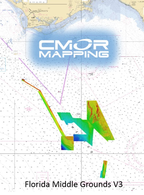
CMOR Mapping MDGR003S
Middle Grounds Simrad
Model: MDGR003S- The Florida Middle Grounds Version 3 CMOR card, released July 17, 2019, now includes a huge expansion of the Florida Middle Grounds (mostly west of the grounds), Expanded Elbow Coverage, 20sq miles East of Clearwater (8-14nm offshore), and the 40 break from steamboat lumps up to the twin ridges. Some of the pipeline is now coverage in great detail.
- The Middle Grounds section covers 1000 square miles, with depths ranging from 75' to 225'.
- The Steam Boat Lumps section covers 150 square miles with depths ranging from 220' to 500'.
- The Elbow section covers 50 square miles with depths ranging from 144' to 215'.
- The 40 Break from Twin Ridges south to Steam Boat Lumps
- Pipeline (north of Steamboat Lumps)
- 20sq miles offshore Clearwater (8-15nm) with depths ranging from 38-55ft.
CMOR cards for Navico products are compatible with:
Lowrance
HDS Gen1 series
HDS Gen2 series (both keypad and touchscreen)
HDS Gen3 series
HDS Carbon
Elite HDI series
Elite CHIRP series
Elite Ti series
HOOK series
Simrad
NSS
NSS evo2
NSS evo3
NSE
NSO
NSO evo2
NSO evo3
GO XSE
GO XSR
Mercury VesselView
502
702
703
903
B&G
Zeus
Zeus Touch
Zeus2
Zeus3
Vulcan
Although the Middle Grounds is among the best fishing and diving areas in the Gulf of Mexico, it's still critical to know where you're going once you invest the time and fuel to make the trip.
CMOR Mapping bathymetry arms you with more and better data than anybody else on the water.
NOAA Chart 11006 is included in the background.
All CMOR Cards except those for Furuno come on Micro SD cards with a standard SD adapter included.
Share